In 1502, on the fourth visit of Christoper Columbus to the Americas, he and his crew landed on the eastern coast of Nicaragua. In 1523, the Spanish explorer, Gil González Dávila arrived on the Pacific coast of Nicaragua where he and his party made contact with the chief of one of tribes, Nicarao, after whom Nicaragua is named. The following year the cities of Leon and Grananda were founded. In 1539, an expedition by Calero y Machuca found the Rio San Juan.
San Juan de Limay is a municipality with a history that stretches back many centuries. It is believed that the first inhabitants of the region were the indigineous people known as the Choroteganos. Pictographs made by these people can be seen just outside of town on rocks along the Rio Queso at an area called “La Bruja (the Witch).†Here a series of hieroglyphics remain on massive stones: the siren, the serpent, the moon, and a carving of the sun that resembles an Aztec calendar. 
A version of the origin of the town comes from a history compiled by journalist Gustavo Vindell Acuña, in his book called “Historical Review of Limay”. He relates that the town was founded by a group of 15 Chorotegas Indians from the vicinity of Esteli who fled from the invasion of native Matagalpas who attacked the population of the pueblo of San Antonio de PavÃa. These first settlers settled along the Limay River, where they left tracks of their culture in the area known as El Chorro.
The first small village that took the name of Limay was located in an area that today is the community of Tranqueras and was called “Great Limay”. Among the first Spanish settlers were Yanuario Castellón, MatÃas Guillén, Juan Sáenz, Teodoro BellorÃn, Liborio Martinez, Alexander, Paulino and Bruno Castellón. Documents show that in 1600, Don Yanuario Castellón purchased 10,000 manzanas of land for “Great Limay”, which he bought from the Captainship of Guatemala.
Two hundred and eighty three years later, the government of doctor José Adán Cárdenas, created a a decree on the 20th of March,1883 for the donation to Limay of 20 “caballerÃas†of land in the area of “Zarca Agua” and “the Hornito”, to rebuild the Municipal Town hall.
The official records from the Departmento de Esteli mentions that in 1860 there is a record of the creation of “Villa Limay†along the Rio Queso.
On the 4th of December 1891, San Juan de Limay was ratified as a municipality when Sacasa Robert, President of Nicaragua, created the department (state) of Estelà which contained the municipalities of the Trinidad, Condega, Pueblo Nuevo, the city of Estelà and, of course, San Juan de Limay. Before the creation of the department of EstelÃ, San Juan de Limay belonged to the province of Great Somoto, that was part of the department of New Segovia, like Condega and New Pueblo.
A German geologist who visited the area in the 1950´s, after studying the mineral wealth of the municipality, said of San Juan de Limay: “This is a poor town, but it is seated in pure gold”. According to earlier narratives, towards 1925 gold production in the area was between 2 and 4 tons every fifteen days. La Grecia, Los Chapetones, El Colorado and LasMinitas, were places with mineral reserves where gold, copper, graphite and marmolina lay in abundance. These reserves were expoited for a time. But then, many of the natural resources, including the forests nearby, were exploited beyond the ability of the ecosystem to keep up.
There is mention also in the writing of Adolph Olivas and Maricely Linarte from which much of the history of Limay is taken, of a former forward thinking mayor of Limay, Federico Rosales, who purchased an electrical plant of German manufacture. He had it transferred to a train from Puerto Corinto and carried it along the RÃo Grande river in the department of León. From there it was dismantled and placed in one hundred carts hauled by oxen to bring it overland to Limay. Rosales created a factory that generated electricity that was used during the period when cotton, the “white spot†as it was called, was planted and cultivated in the valley.
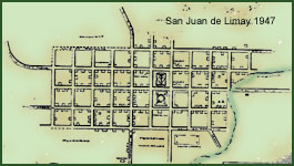
Map source www.manfut.org – used wth permission.
Photograph by Howdy Burns